Hiking two weekends in a row! Woot!
This last weekend my mom and I hiked together in Peter Lougheed Provincial Park. The hike we did was to Rawson Lake. It's a trail through the woods with a steady incline and when it begins to level there are planks to keep you out of the water left from melted snow. You arrive at your destination and step through the trees to see the lake and the splendor of the mountains so near and it's stunning! I must emphasize that you don't have to summit a mountain in order to take in an amazing view!
Rawson Lake
Difficulty: moderate*
Round trip: 7.8 km
Hiking Time: 2-4 hrs
Elevation Gain: 300 m
FitBit: approx 13,100 steps and 120 floors
The Rawson Lake trail actually starts out on the same path as the Upper Kananaskis Lakes trail but splits shortly after the waterfall. Before you get to the waterfall there are breaks in the trees and the views of Upper Kananaskis Lake are beautiful on a clear day! At the waterfall you will be reminded of the devastation of the flood of spring 2013. There used to be a bridge of which there is no sign of. Climb carefully down the rocks towards the river and you'll see where people have created a makeshift bridge out of two larger tree trunks. You will need to traverse these and step on a few rocks to make it to the other side. It may be nerve wracking, but it can be done! We saw numerous people of all ages go across. This included one feeble looking little senior lady who used a walking stick in each hand to keep her balance. I figure if she can, I sure can!

Once across the river head back to the tree line and look for the opening in the trees for the new path created. Take a right, away from the falls, and continue on your way. Not too far after you'll come to a fork, but there is a sign to point the way! Take a left and start your ascent. It's a steady incline with a few switch backs, not much to see other than forest, but if you stop and listen you can hear some birds :)
Now this will depend on the time of year that you go, but for us in early June, nearing the top, we came across the snow which only becomes deeper as you continue. The middle of the path was a packed ice ridge so caution is necessary so as not to slip. To the sides of the ice the snow was melted because it hadn't been packed down, but it's also a mucky wet mess. So this is your fair warning to wear proper footwear! As we hiked we saw a girl coming down alone, she was in summer sandals and her feet were muddy and wet, not very fun for her I'm sure :(
As you continue there are wooden planks to keep you above the melted snow, but some at this time parts were still covered in ice. Don't get me wrong, this doesn't mean you shouldn't do this hike! But now knowing the conditions I'd recommend going in the late summer or early fall to make it a little easier and enjoyable.
We were almost to our destination when were were passing a family and the man said, "We saw a bear!" ... brief pause, "on TV last night". He howled so loud and we could hear him laughing long after we passed them. Sure it gave us a little shock, but also a chuckle because he thought he was so funny. Thankfully this hike was full of other people, more than I could even guess a number to tell you. It's a popular one for sure so hopefully bears would be deterred from the area. However, we are in their territory so it never hurts to take precautions. Take bear spray. Always. Learn how to use it and take it. Just do it.
Once you reach the lake the view is spectacular! Peek through the trees and snap some pictures and don't turn around yet because you can keep going around the lake (there's actually an outhouse if you so need) and get a nice open view of the lake and the base of the mountain. I think you can follow the tree line around, but because no one had trudged a path through the snow before us, we opted to scramble up the rocky/mossy hill. It looks more scary than it is so don't be deterred.

 We sat up on the hill for lunch and it was wonderful. I was amazed that I could be out in my shorts and tank top (the forecast had been +27) and even though there was snow I was not chilled at all! We enjoyed the sun, the warm wind, the company of some chipmunks and marmots, and most of all God's magnificent mountainous creation in front of us before we began our hike back.
Happy Hiking!

*The book labeled this hike as easy, but that was before the flood where now there is no bridge to cross the river, plus I also think they hiked it in the summer when there was no snow and ice on the paths so I rank it as moderate. However, if you are a spry 20-30 something adult I'm sure you might rank it easy.
 |
| Rawson Lake at the base of Mt. Sarrail |
Rawson Lake
Difficulty: moderate*
Round trip: 7.8 km
Hiking Time: 2-4 hrs
Elevation Gain: 300 m
FitBit: approx 13,100 steps and 120 floors
 |
| Upper Kananaskis Lake |
The Rawson Lake trail actually starts out on the same path as the Upper Kananaskis Lakes trail but splits shortly after the waterfall. Before you get to the waterfall there are breaks in the trees and the views of Upper Kananaskis Lake are beautiful on a clear day! At the waterfall you will be reminded of the devastation of the flood of spring 2013. There used to be a bridge of which there is no sign of. Climb carefully down the rocks towards the river and you'll see where people have created a makeshift bridge out of two larger tree trunks. You will need to traverse these and step on a few rocks to make it to the other side. It may be nerve wracking, but it can be done! We saw numerous people of all ages go across. This included one feeble looking little senior lady who used a walking stick in each hand to keep her balance. I figure if she can, I sure can!

 |
| View looking down from the base of the waterfall, flood devastation apparent. |
 |
| Upper Kananaskis Lake, river crossing on the right |
 |
| A makeshift bridge, balance required, but doable! |
Now this will depend on the time of year that you go, but for us in early June, nearing the top, we came across the snow which only becomes deeper as you continue. The middle of the path was a packed ice ridge so caution is necessary so as not to slip. To the sides of the ice the snow was melted because it hadn't been packed down, but it's also a mucky wet mess. So this is your fair warning to wear proper footwear! As we hiked we saw a girl coming down alone, she was in summer sandals and her feet were muddy and wet, not very fun for her I'm sure :(
As you continue there are wooden planks to keep you above the melted snow, but some at this time parts were still covered in ice. Don't get me wrong, this doesn't mean you shouldn't do this hike! But now knowing the conditions I'd recommend going in the late summer or early fall to make it a little easier and enjoyable.
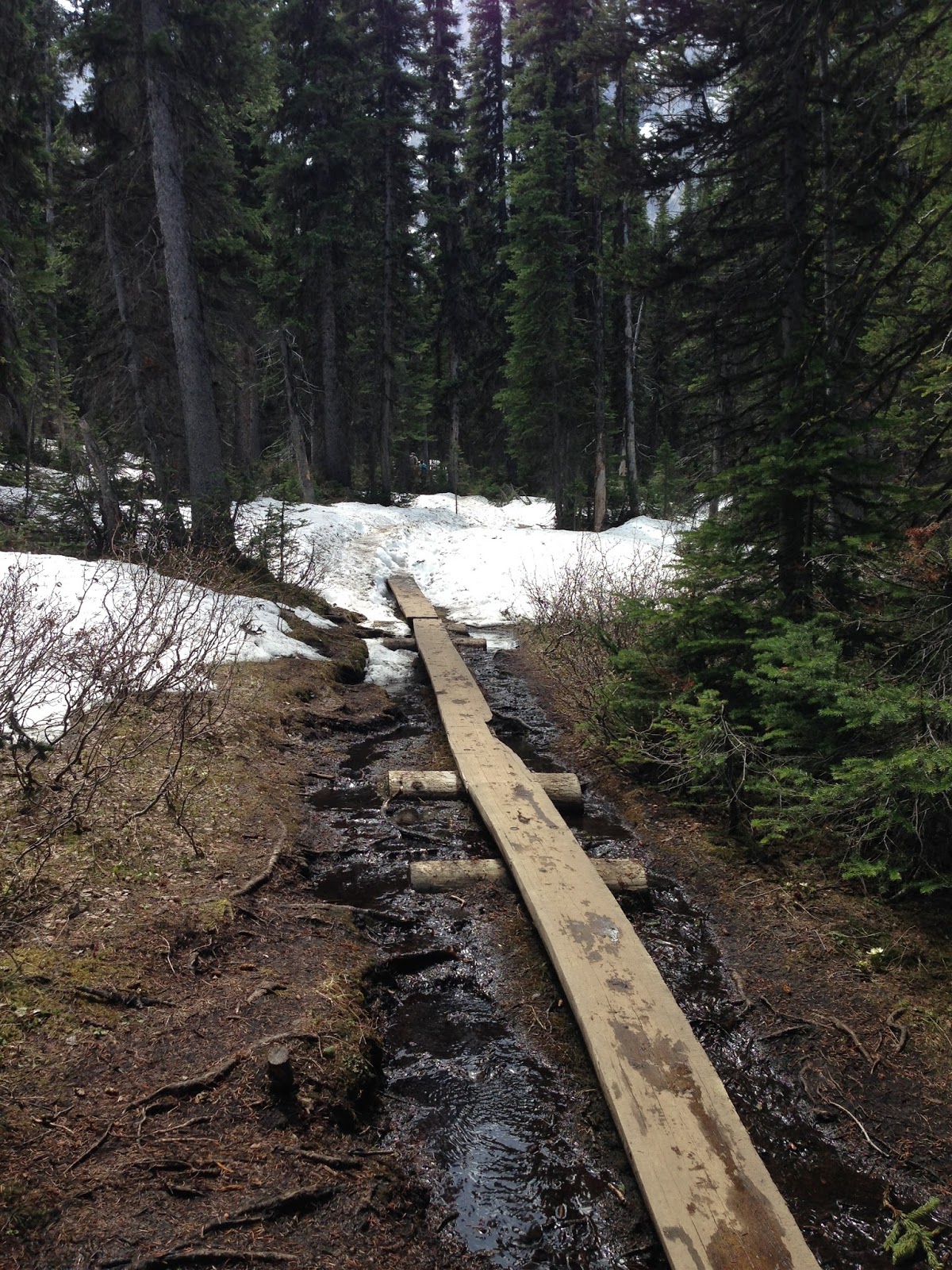 |
| A part of the plank walk, but note some is still covered in ice and snow and other parts are surrounded by water. |
Once you reach the lake the view is spectacular! Peek through the trees and snap some pictures and don't turn around yet because you can keep going around the lake (there's actually an outhouse if you so need) and get a nice open view of the lake and the base of the mountain. I think you can follow the tree line around, but because no one had trudged a path through the snow before us, we opted to scramble up the rocky/mossy hill. It looks more scary than it is so don't be deterred.
 |
| Rawson Lake in early June |


 |
| The view away from Mt. Sarrail |
 |
| Don't forget to enjoy what's underfoot too! |
Happy Hiking!
*The book labeled this hike as easy, but that was before the flood where now there is no bridge to cross the river, plus I also think they hiked it in the summer when there was no snow and ice on the paths so I rank it as moderate. However, if you are a spry 20-30 something adult I'm sure you might rank it easy.


You are blessed to enjoy God's splendor with your Mom !
ReplyDeleteYes I am :) Thanks Candis!
Delete